PulsePath
The Project
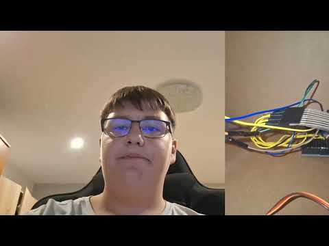
PulsePath is a wearable haptic navigation and environmental awareness device designed to help individuals with hearing impairments safely navigate the world through real-time vibrational feedback. The device works alongside a mobile application and uses embedded sensors to detect approaching obstacles, vehicles, and navigation directions. Instead of relying on sound-based alerts, PulsePath communicates through vibration patterns. For example, if a vehicle is approaching from behind while a user is crossing the street, the device vibrates in a specific direction to alert the user. Beyond safety, PulsePath also provides navigation assistance all via vibration, so users can bike, run, or walk without constantly checking their phones. Through left or right vibration, users would be notified to turn in the correct direction at intersections. The inspiration for this project came from my childhood experiences accompanying my father to his hearing-aid retail stores. Growing up, I observed the daily struggles hearing-impaired individuals faced when interacting with environments designed around sound. These experiences stayed with me and eventually connected with my interests in engineering and applied science. This project is also deeply connected to my community involvement. I founded a nonprofit organization called Echoes of Equality, where I organize hearing test sessions and assist individuals with hearing-aid adjustments at deaf centers. Through these experiences, I gained a deeper understanding of hearing loss, audiograms, and how different people perceive sound frequencies differently. One of the most difficult aspects of the project was building the navigation system. I wanted users to have the familiar visual experience of Google Maps while still supporting custom turn-by-turn routing directly within my application. Since Google Cloud Platform did not provide the flexibility I needed for navigation and waypoint integration, I built my own routing infrastructure using OSRM (Open Source Routing Machine) combined with OpenStreetMap data. Setting up the backend required processing raw map data through extraction, partitioning, and contraction stages to optimize route calculations. On the client side, I developed a Flutter-based routing service that decodes OSRM polyline data, converts routing maneuvers into vibration-based navigation instructions, and synchronizes them with Google Maps visuals. Another challenge involved improving responsiveness and reliability. I tested multiple microcontrollers, including the ESP32-S3 and RP2040, measuring Bluetooth latency, power consumption, and real-time performance. After optimization, I reduced BLE latency from 150ms to 50ms, significantly improving response speed. I also implemented off-route detection with hysteresis to prevent unnecessary rerouting caused by GPS instability. These technical improvements were essential to making PulsePath practical and reliable for real-world use.

About the team
Team members
More cool Hardware projects
MONEY
Hardware
Micro:bit Calculator
Hardware
Binardo Binstein
Hardware